Now that I moved my little home brew antenna outside, I'm picking up aircraft tracks out to 150 miles away. Most of them are pretty mundane; scheduled airlines, charter flights, student pilots and LifeLine flights. One that caught my eye the other day was an aircraft at 8,000', doing 35 knots. Wondering if the speed was a glitch, I looked up the tail number and found out it was a glider registered at the Owl Canyon Gliderport. I didn't look closely at his flight profile, but a glider could easily do those kinds of numbers into a headwind.
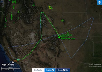
Anyway.....One plane really grabbed my attention tonight, a NASA 747 with a very unusual flight plan track.
The solid green line is where he's been, and the dotted line is where he's going, per the filed flight plan. Departure and landing the sites were both listed as "Palmdale", so it's anybody's guess what they're doing tonight. Must be a "Chemtrail" run. That's why they do it at night now, so people can't see them!
And anywhoo....Mother and child are doing fine. The new parents were treated to a "Surf and Turf" dinner tonight courtesy of the hospital, but TLG didn't get to meet his new little brother as I originally thought. Strict rules are in place, and the only people who get into the Natal ICU are Mommy and Daddy. The NLG is doing fine, breathing without assistance, eyes open, looking around, and eating like a horse per his Mom and Dad.
But he's soooo tiny!
I'll post some pix as soon as SLW sends them.

%20PiAware%20SkyAware.png)

I've been interested in monitoring UAT, on 978 MHz. I know it's within the range of my RTL-SDR (like 1090 ADS-B), but haven't looked into the software side.
ReplyDeleteUAT was conceived of as an add-on for smaller planes that might enable things like transmitting up weather radar info as well as ADS-B type tracking. The Air Transport class aircraft have their own weather radars, but smaller Gen Av planes sometimes don't and the smallest private planes absolutely don't.
They make mention of that on the PiAware site. I'm a rookie, so I'm just going with the 1090MHz stuff. Made another improvement the other night. One of the lengths of coax I was using just came out of a box in the basement, and it looked a bit tatty. Made up a new one, and saw another increase in signal strength.
DeleteThe old piece of cable went in the trash.....
Looks like the 747 could have been on an astronomical observation run.
ReplyDeleteI'm not sure which NASA 747 it was was. At first I thought it was the shuttle carrier, and then remembered they haven't flown that one in quite a while!
DeleteN747NA was the aircraft, and it's the SOFIA (Stratospheric Observatory For Infrared Astronomy) aircraft.
Deletehttps://en.wikipedia.org/wiki/Stratospheric_Observatory_for_Infrared_Astronomy
And I just read that in June/July it gets moved to Christchurch, so maybe this was a Test/Calibration run before they ferry it down there.
DeleteGood news on the grandchild!
ReplyDeleteMy sister flew into DIA last night/early morning on Southwest. Seems Southwest's computers in Denver crashed and every flight was late. The scene at DIA last night was one gigantic cluster**ck. Must have made for some unusual aircraft tracks.
I'm too new at this to pick up differences caused by something like that. I'm still at the "Look! Airplanes on the screen!" stage....:-)
DeleteLOL, you keep looking up 'those' flights, you'll end up on another list... just sayin... And good news on the grandbaby!
ReplyDeleteHAH! I've seen a few military aircraft, but not many. A couple of C-17's and some "Gulfstream" type mil transports, but nothing unusual. There's an aerial refueling track on the CO/WY border, but haven't seen anything there yet.
DeleteNLG is doing fine. Finally got some pix so I'll get those up today.
Plan on feeding any sites like https://globe.adsbexchange.com/ ?
ReplyDeleteOr just personal amusement...?
I find that site as useful as lightningmaps.org for what's going on overhead....
It gets fed to FlightAware, but was mostly for my own amusement.
DeleteThere's a glider up at FIFTY-SIX THOUSAND FEET right now down by Boulder, CO.
That's a Raven Aerostar balloon -
Deletehttps://globe.adsbexchange.com/?icao=a2609d
It's had quite the day....
I usually see them out of the Sioux Falls area - first one I've noticed out this way....
Is it a balloon, or an aerostat? The altitude caught my eye immediately, and having a tail number, I assumed it was a glider.
DeleteFree balloons need an FAA number? Interesting....
Now...you're getting technical and I have to ask the Duck....Raven does both it looks like
ReplyDeletehttps://ravenaerostar.com/products
But Aerostat would seem to imply the tethered version - and when I first caught this one the track went back to mid-Kansas
N# registration rules I'm not sure of either - but I could see it for ATC following as they transit regular routes - they went to the trouble of the ADSB xmtr so why not...
Yes, you're correct. An aeroSTAT is tethered, like the WWII "Barrage Balloons".
DeleteWhich occurred to me a few seconds after I asked the question!
The track first showed up here over Lamar, CO.
AND....the icon on FlightAware changed to a balloon. Guess they know more than I do!
The ADSBExchange tracks go back a little farther in time - I noticed it NE of Garden City, KS
ReplyDeleteIf there was a little light you'd be able to see it about now - no idea if they light them at all
According to the current position at 0355UTC, he's two miles from here, at 54,000 feet.
DeleteIf they lit these things up it would be the 1950's UFO sightings all over again.....